|
|
Antenna Structure Registration 1047886 |
 |
Registration Info | Registration Number: 1047886 |
| File Number: A1366469 |
| FAA Study: 86-ASW-0755-OE |
| FAA Issue Date: 07/07/1986 |
| Status: Constructed |
| Date Constructed: 12/01/1986 |
| FAA EMI: N |
| NEPA: N |
Structure Info
| Structure Type: TOWER |
| Structure Coordinates: 32-3-41.0 N 95-18-51.0 W (NAD 83) |
| Structure Coordinates: 32-03-40.4 N 95-18-50.2 W (Converted to NAD 27) |
| Structure Address: 1.8 Mi W Of Mount Selmand And S Of Hwy 855 |
| Structure City: Mount Selman, TX |
| Structure County: Cherokee County |
| Painting & Lighting Info |
FAA Circular #: 70/7460-1G |
FAA Chapters: 4, 6, 9 |
Remarks: 24 HOUR HIGH INTENSITY WHITE LIGHTS |
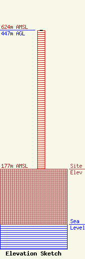
| Elevation Info |
Site Elevation: 177 meters (581 ft) |
| Height of Structure: 445 meters (1460 feet) |
| Overall Height Above Ground: 447 meters (1467 feet) |
| Overall Height Above Mean Sea Level: 624 meters (2047 feet) |
| Owner Info | Pinnacle Towers LLC
2000 Corporate Drive
Canonsburg, PA 15317
(724) 416-2400
Regulatory.Department@crowncastle.com |
| Contact Info | Crown Castle
2000 Corporate Drive
Canonsburg, PA 15317
Tom Anderson
(724) 743-6330
Tom.Anderson@crowncastle.com |
