|
|
Antenna Structure Registration 1047920 |
 |
Registration Info | Registration Number: 1047920 |
| File Number: A1063775 |
| FAA Study: 82-ASW-3133-OE |
| FAA Issue Date: 02/02/1983 |
| Status: Constructed |
| Date Constructed: 10/29/1984 |
| FAA EMI: N |
| NEPA: N |
Structure Info
| Structure Type: TOWER |
| Structure Coordinates: 31-47-46.0 N 106-28-59.0 W (NAD 83) |
| Structure Coordinates: 31-47-45.6 N 106-28-57.0 W (Converted to NAD 27) |
| Structure Address: 2201 Wyoming |
| Structure City: El Paso, TX |
| Structure County: El Paso County |
| Painting & Lighting Info |
FCC Paragraph(s): 1, 3, 12, 21 |
Remarks: RED LIGHTS/PAINT |
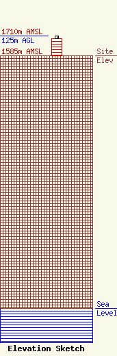
| Elevation Info |
Site Elevation: 1585 meters (5200 ft) |
| Height of Structure: 107.3 meters (352 feet) |
| Overall Height Above Ground: 125 meters (410 feet) |
| Overall Height Above Mean Sea Level: 1710 meters (5610 feet) |
| Owner Info | KDBC Licensee, LLC
Pillsbury Winthrop Shaw Pittman LLP
Washington, DC 20036
(202) 663-8195
miles.mason@pillsburylaw.com |
| Contact Info | KDBC Licensee, LLC
Pillsbury Winthrop Shaw Pittman LLP
Washington, DC 20036
(202) 663-8195
miles.mason@pillsburylaw.com |
