|
|
Antenna Structure Registration 1048117 |
 |
Registration Info | Registration Number: 1048117 |
| File Number: A0056609 |
| FAA Study: 98-AEA-1820-OE |
| FAA Issue Date: 07/15/1998 |
| Status: Constructed |
| Date Constructed: 01/01/1998 |
| NEPA: N |
Structure Info
| Structure Type: 3TA3 |
| Structure Coordinates: 36-36-34.0 N 82-9-22.0 W (NAD 83) |
| Structure Coordinates: 36-36-33.6 N 82-09-22.5 W (Converted to NAD 27) |
| Structure Address: Twr 3 - On Valley Dr 2.9 Km Ne |
| Structure City: Bristol, VA |
| Structure County: Bristol city |
| Painting & Lighting Info |
FAA Circular #: 70/7460-1J |
FAA Chapters: 3, 4, 5, 13 |
| Elevation Info |
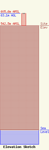
Site Elevation: 542.5 meters (1780 ft) |
| Height of Structure: 62.2 meters (204 feet) |
| Overall Height Above Ground: 63.1 meters (207 feet) |
| Overall Height Above Mean Sea Level: 605.6 meters (1987 feet) |
| Owner Info | BRISTOL BROADCASTING CO INC
1389
BRISTOL, VA 24203
(540) 669-8112
|
