|
|
Antenna Structure Registration 1048118 |
 |
Registration Info | Registration Number: 1048118 |
| File Number: A0056610 |
| FAA Study: 98-ASO-5219-OE |
| FAA Issue Date: 08/13/1998 |
| Status: Constructed |
| Date Constructed: 01/01/1998 |
| NEPA: N |
Structure Info
| Structure Type: 3TA1 |
| Structure Coordinates: 37-0-52.0 N 88-36-50.0 W (NAD 83) |
| Structure Coordinates: 37-00-51.8 N 88-36-49.8 W (Converted to NAD 27) |
| Structure Address: Twr 1 - Old Mayfield Rd 7.2 Km S |
| Structure City: Paducah, KY |
| Structure County: McCracken County |
| Painting & Lighting Info |
FAA Circular #: 70/7460-1J |
FAA Chapters: 3, 13 |
Remarks: 3TA. NO CHANGE TO MARKING OR LIGHTING. |
| Elevation Info |
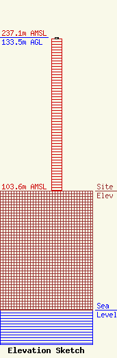
Site Elevation: 103.6 meters (340 ft) |
| Height of Structure: 132.6 meters (435 feet) |
| Overall Height Above Ground: 133.5 meters (438 feet) |
| Overall Height Above Mean Sea Level: 237.1 meters (778 feet) |
| Owner Info | BRISTOL BROADCASTING CO INC
1389
BRISTOL, VA 24203
(540) 669-8112
|
