|
|
Antenna Structure Registration 1048236 |
 |
Registration Info | Registration Number: 1048236 |
| File Number: A1348052 |
| FAA Study: 2023-AEA-15164-OE |
| FAA Issue Date: 02/14/2024 |
| Status: Constructed |
| Date Constructed: 01/01/1974 |
| NEPA: N |
Structure Info
| Structure Type: GTOWER |
| Structure Coordinates: 42-27-54.2 N 76-22-22.3 W (NAD 83) |
| Structure Coordinates: 42-27-53.9 N 76-22-23.5 W (Converted to NAD 27) |
| Structure Address: 0.6 Miles Northwest Of Mount Pleasant Rd & Mineah Rd |
| Structure City: Dryden, NY |
| Structure County: Tompkins County |
| Painting & Lighting Info |
FAA Circular #: 70/7460-1M |
FAA Chapters: 4, 8, 15 |
Remarks: PRIOR STUDY 2011-AEA-3129-OE |
| Elevation Info |
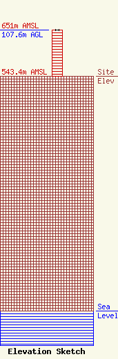
Site Elevation: 543.4 meters (1783 ft) |
| Height of Structure: 106.7 meters (350 feet) |
| Overall Height Above Ground: 107.6 meters (353 feet) |
| Overall Height Above Mean Sea Level: 651 meters (2136 feet) |
| Owner Info | GTC Uno, LLC
PO Box 2359
Ponte Vedra Beach, FL 32004
(844) 482-8977
regulatory@gtctowers.com |
| Contact Info | GTC Uno, LLC
PO Box 2359
Ponte Vedra Beach, FL 32004
(844) 482-8977
regulatory@gtctowers.com |
