|
|
Antenna Structure Registration 1048276 |
 |
Registration Info | Registration Number: 1048276 |
| File Number: A0984408 |
| Status: Constructed |
| Date Constructed: 01/01/1968 |
| FAA EMI: N |
| NEPA: N |
Structure Info
| Structure Type: 2TA2 |
| Structure Coordinates: 35-56-17.0 N 79-1-35.0 W (NAD 83) |
| Structure Coordinates: 35-56-16.5 N 79-01-36.0 W (Converted to NAD 27) |
| Structure Address: Twr 2 - 1721 E Franklin St |
| Structure City: Chapel Hill, NC |
| Structure County: Orange County |
| Painting & Lighting Info |
FCC Paragraph(s): 1, 3, 11, 21 |
| Elevation Info |
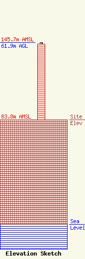
Site Elevation: 83.8 meters (275 ft) |
| Height of Structure: 61 meters (200 feet) |
| Overall Height Above Ground: 61.9 meters (203 feet) |
| Overall Height Above Mean Sea Level: 145.7 meters (478 feet) |
| Owner Info | RUDD MEDIA, LLC
2416 E. 37TH ST. N.
WICHITA, KS 67219
(316) 847-4886
angie.gregory@lrico.com |
| Info |
