|
|
Antenna Structure Registration 1048576 |
 |
Registration Info | Registration Number: 1048576 |
| File Number: A0916118 |
| FAA Study: 2014-ASW-5240-OE |
| FAA Issue Date: 07/30/2014 |
| Status: Constructed |
| Date Constructed: 04/01/1992 |
| FAA EMI: N |
| NEPA: N |
Structure Info
| Structure Type: GTOWER |
| Structure Coordinates: 29-17-56.8 N 95-14-12.1 W (NAD 83) |
| Structure Coordinates: 29-17-55.9 N 95-14-11.3 W (Converted to NAD 27) |
| Structure Address: 4525 County Road 197 (#30326) |
| Structure City: Alvin, TX |
| Structure County: Brazoria County |
| Painting & Lighting Info |
FAA Circular #: 70/7460-1K |
FAA Chapters: 4, 7, 12 |
Remarks: PRIOR STUDY 2005-ASW-3106-OE |
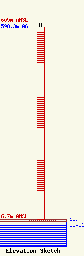
| Elevation Info |
Site Elevation: 6.7 meters (22 ft) |
| Height of Structure: 586.7 meters (1925 feet) |
| Overall Height Above Ground: 598.3 meters (1963 feet) |
| Overall Height Above Mean Sea Level: 605 meters (1985 feet) |
| Owner Info | American Towers LLC
10 Presidential Way
Woburn, MA 01801
(678) 564-3236
faa-fcc@americantower.com |
| Contact Info | American Towers, LLC.
10 Presidential Way
Woburn, MA 01801
(678) 564-3236
faa-fcc@americantower.com |
