|
|
Antenna Structure Registration 1048808 |
 |
Registration Info | Registration Number: 1048808 |
| File Number: A0568264 |
| FAA Study: 98-ASO-2368-OE |
| FAA Issue Date: 05/11/1998 |
| Status: Constructed |
| Date Constructed: 01/01/1966 |
| FAA EMI: N |
| NEPA: N |
Structure Info
| Structure Type: TOWER |
| Structure Coordinates: 38-13-18.0 N 84-54-54.0 W (NAD 83) |
| Structure Coordinates: 38-13-17.7 N 84-54-54.2 W (Converted to NAD 27) |
| Structure Address: Us 421 & St. John Rd, On John Hamilton Farm |
| Structure City: Frankfort, KY |
| Structure County: Franklin County |
| Painting & Lighting Info |
FAA Chapters: NONE |
| Elevation Info |
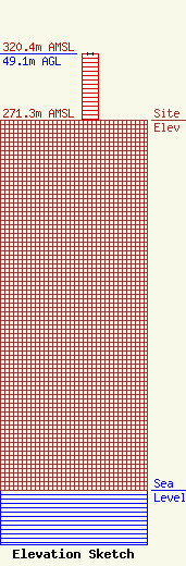
Site Elevation: 271.3 meters (890 ft) |
| Height of Structure: 48.9 meters (160 feet) |
| Overall Height Above Ground: 49.1 meters (161 feet) |
| Overall Height Above Mean Sea Level: 320.4 meters (1051 feet) |
| Owner Info | Forever Communications, Inc.
1919 Scottsville Road
Bowling Green, KY 42104
(270) 843-3333
chris@forevercomm.com |
| Info |
