|
|
Antenna Structure Registration 1048836 |
 |
Registration Info | Registration Number: 1048836 |
| File Number: A1206155 |
| FAA Study: 98-ASW-1304-OE |
| Status: Dismantled |
| Date Constructed: 11/18/1997 |
| NEPA: N |
Structure Info
|
| Structure Coordinates: 31-29-30.0 N 100-26-6.0 W (NAD 83) |
| Structure Coordinates: 31-29-29.4 N 100-26-04.7 W (Converted to NAD 27) |
| Structure Address: Tx-2800 Armstrong |
| Structure City: San Angelo, TX |
| Structure County: Tom Green County |
| Painting & Lighting Info |
FCC Paragraph(s): 1, 3, 4, 13, 21 |
| Elevation Info |
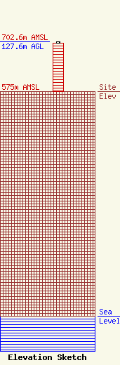
Site Elevation: 575 meters (1886 ft) |
| Height of Structure: 124.2 meters (407 feet) |
| Overall Height Above Ground: 127.6 meters (419 feet) |
| Overall Height Above Mean Sea Level: 702.6 meters (2305 feet) |
| Owner Info | Nexstar Media Inc.
545 E. John Carpenter Freeway
Irving, TX 75062
(972) 373-8800
jasroberts@nexstar.tv |
| Contact Info | Nexstar Media Inc.
545 E. John Carpenter Freeway
Irving, TX 75062
Jason Roberts
(972) 373-8800
jasroberts@nexstar.tv |
