|
|
Antenna Structure Registration 1048931 |
 |
Registration Info | Registration Number: 1048931 |
| File Number: A1182358 |
| FAA Study: 2002-ASW-5969-OE |
| FAA Issue Date: 02/03/2003 |
| Status: Constructed |
| Date Constructed: 03/28/2003 |
| FAA EMI: N |
| NEPA: N |
Structure Info
| Structure Type: TOWER |
| Structure Coordinates: 36-1-36.0 N 95-40-45.0 W (NAD 83) |
| Structure Coordinates: 36-01-35.6 N 95-40-44.1 W (Converted to NAD 27) |
| Structure Address: 9250 S. 273rd E. Ave. |
| Structure City: Broken Arrow, OK |
| Structure County: Wagoner County |
| Painting & Lighting Info |
FCC Paragraph(s): A1, B, E, H |
Remarks: OM&L TO REMAIN 24 HR HI STROBES AS PER PRIOR STUDY 78-ASW-1548-OE |
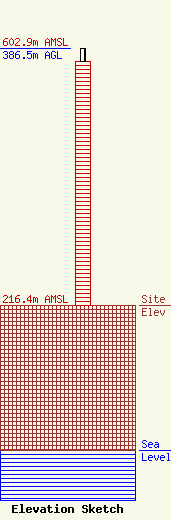
| Elevation Info |
Site Elevation: 216.4 meters (710 ft) |
| Height of Structure: 365.8 meters (1200 feet) |
| Overall Height Above Ground: 386.5 meters (1268 feet) |
| Overall Height Above Mean Sea Level: 602.9 meters (1978 feet) |
| Owner Info | American Towers LLC
10 Presidential Way
Woburn, MA 01801
(781) 926-4500
faa-fcc@americantower.com |
| Contact Info | American Towers LLC
10 Presidential Way
Woburn, MA 01801
(781) 926-4500
faa-fcc@americantower.com |
