|
|
Antenna Structure Registration 1049271 |
 |
Registration Info | Registration Number: 1049271 |
| File Number: A1344413 |
| FAA Study: 2020-ASO-31485-OE |
| FAA Issue Date: 12/02/2020 |
| Status: Constructed |
| Date Constructed: 05/01/1997 |
| NEPA: N |
Structure Info
| Structure Type: GTOWER |
| Structure Coordinates: 35-12-25.2 N 85-17-11.1 W (NAD 83) |
| Structure Coordinates: 35-12-24.9 N 85-17-11.2 W (Converted to NAD 27) |
| Structure Address: 1338 Sawyer Cemetary Rd / Us-tn-5018 |
| Structure City: Chattanooga, TN |
| Structure County: Hamilton County |
| Painting & Lighting Info |
FAA Circular #: 70/7460-1L |
FAA Chapters: 4, 8, 12 |
Remarks: OM&L to remain the same as prior study = A MED-DUAL SYSTEM |
Remarks: PRIOR STUDY 2016-ASO-27785-OE |
Remarks: OM&L to remain the same as prior study = A MED-DUAL SYSTEM |
Remarks: PRIOR STUDY 2016-ASO-27785-OE |
| Elevation Info |
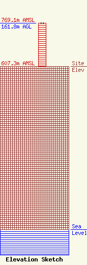
Site Elevation: 607.3 meters (1992 ft) |
| Height of Structure: 161.6 meters (530 feet) |
| Overall Height Above Ground: 161.8 meters (531 feet) |
| Overall Height Above Mean Sea Level: 769.1 meters (2523 feet) |
| Owner Info | Vertical Bridge CC FM, LLC
22 W Atlantic Avenue
Delray Beach, FL 33444
(561) 406-4015
fcc-faa@verticalbridge.com |
| Contact Info | Vertical Bridge CC FM, LLC
22 W Atlantic Avenue
Delray Beach, FL 33444
Richard Hickey
(561) 406-4015
fcc-faa@verticalbridge.com |
