|
|
Antenna Structure Registration 1049484 |
 |
Registration Info | Registration Number: 1049484 |
| File Number: A1192420 |
| FAA Study: 2002-ASO-6609-OE |
| FAA Issue Date: 01/17/2003 |
| Status: Constructed |
| Date Constructed: 03/03/2003 |
| FAA EMI: N |
| NEPA: N |
Structure Info
| Structure Type: TOWER |
| Structure Coordinates: 34-47-30.9 N 81-16-5.3 W (NAD 83) |
| Structure Coordinates: 34-47-30.4 N 81-16-06.0 W (Converted to NAD 27) |
| Structure Address: Armenia Rd, Chester County |
| Structure City: Lowrys, SC |
| Structure County: Chester County |
| Painting & Lighting Info |
FAA Circular #: 70/7460-1K |
FAA Chapters: 4, 6, 12 |
Remarks: PRIOR STUDY 2002-ASO-3453-OE. STRUCTURE REACHED ITS GREATEST HEIGHT ON 3/3/03 PER SUPPLEMENTAL NOTICE DATED 3/8/03. |
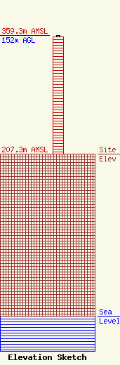
| Elevation Info |
Site Elevation: 207.3 meters (680 ft) |
| Height of Structure: 150.8 meters (495 feet) |
| Overall Height Above Ground: 152 meters (499 feet) |
| Overall Height Above Mean Sea Level: 359.3 meters (1179 feet) |
| Owner Info | Charlotte Broadcasting, LLC
1010 Wayne Avenue, 14th Floor
Silver Spring, MD 20910
(301) 429-3254
gstrickland@radio-one.com |
| Contact Info | Urban One, Inc.
1010 Wayne Avenue, 14th Floor
Silver Spring, MD 20910
Greg Strickland
(301) 429-3254
gstrickland@radio-one.com |
