|
|
Antenna Structure Registration 1049882 |
 |
Registration Info | Registration Number: 1049882 |
| File Number: A1121444 |
| FAA Study: 89-AGL-518-OE |
| FAA Issue Date: 06/16/1989 |
| Status: Constructed |
| Date Constructed: 01/01/1945 |
| FAA EMI: N |
| NEPA: N |
Structure Info
| Structure Type: TOWER |
| Structure Coordinates: 44-26-58.0 N 95-45-43.0 W (NAD 83) |
| Structure Coordinates: 44-26-58.1 N 95-45-41.9 W (Converted to NAD 27) |
| Structure Address: 1414 E College Dr |
| Structure City: Marshall, MN |
| Structure County: Lyon County |
| Painting & Lighting Info |
FCC Paragraph(s): 1, 3, 12, 21 |
Remarks: RED LIGHTS/PAINT |
| Elevation Info |
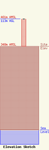
Site Elevation: 348 meters (1142 ft) |
| Height of Structure: 112 meters (367 feet) |
| Overall Height Above Ground: 113 meters (371 feet) |
| Overall Height Above Mean Sea Level: 461 meters (1512 feet) |
| Owner Info | Subarctic Realty, LLC
5825 SW 91st Street
Miami, FL 33156
(507) 904-4000
j.david.linder@gmail.com |
| Contact Info | Subarctic Realty, LLC
5825 SW 91st Street
Miami, FL 33156
(507) 904-4000
j.david.linder@gmail.com |
