|
|
Antenna Structure Registration 1050329 |
 |
Registration Info | Registration Number: 1050329 |
| File Number: A0654528 |
| FAA Study: 88-ASO-2171-OE |
| FAA Issue Date: 06/02/1989 |
| Status: Constructed |
| Date Constructed: 07/20/1991 |
| FAA EMI: N |
| NEPA: N |
Structure Info
| Structure Type: TOWER |
| Structure Coordinates: 34-28-28.0 N 88-43-41.0 W (NAD 83) |
| Structure Coordinates: 34-28-27.6 N 88-43-40.8 W (Converted to NAD 27) |
| Structure Address: 5 Miles West Of Guntown, Ms Then 1 Mile North At Blair Community |
| Structure City: Guntown, MS |
| Structure County: Lee County |
| Painting & Lighting Info |
FAA Circular #: 70/7460-1G |
FAA Chapters: 3, 4, 5, 9 |
| Elevation Info |
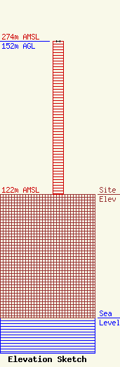
Site Elevation: 122 meters (400 ft) |
| Height of Structure: 152 meters (499 feet) |
| Overall Height Above Ground: 152 meters (499 feet) |
| Overall Height Above Mean Sea Level: 274 meters (899 feet) |
| Owner Info | AMERICAN FAMILY ASSOCIATION
P.O. DRAWER 2440
TUPELO, MS 38803
(662) 844-8888
JES@AFA.NET |
