|
|
Antenna Structure Registration 1050334 |
 |
Registration Info | Registration Number: 1050334 |
| File Number: A1344408 |
| FAA Study: 98-ASO-721-OE |
| FAA Issue Date: 06/11/1998 |
| Status: Constructed |
| Date Constructed: 06/01/1994 |
| FAA EMI: N |
| NEPA: N |
Structure Info
| Structure Type: TOWER |
| Structure Coordinates: 27-33-19.0 N 80-22-6.0 W (NAD 83) |
| Structure Coordinates: 27-33-17.9 N 80-22-06.8 W (Converted to NAD 27) |
| Structure Address: 6690 North Us #1 |
| Structure City: Fort Pierce, FL |
| Structure County: St. Lucie County |
| Painting & Lighting Info |
FAA Circular #: 70/7460-1J |
FAA Chapters: 4, 6, 13 |
Remarks: Removed final date from determination. Scenario 3./jjs/case#635066 |
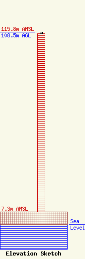
| Elevation Info |
Site Elevation: 7.3 meters (24 ft) |
| Height of Structure: 107.5 meters (353 feet) |
| Overall Height Above Ground: 108.5 meters (356 feet) |
| Overall Height Above Mean Sea Level: 115.8 meters (380 feet) |
| Owner Info | Vertical Bridge CC FM, LLC
22 W Atlantic Avenue
Delray Beach, FL 33444
(561) 406-4015
fcc-faa@verticalbridge.com |
| Contact Info | Vertical Bridge CC FM, LLC
22 W Atlantic Avenue
Delray Beach, FL 33444
Richard Hickey
(561) 406-4015
fcc-faa@verticalbridge.com |
