|
|
Antenna Structure Registration 1051020 |
 |
Registration Info | Registration Number: 1051020 |
| File Number: A0780541 |
| FAA Study: 98-ASW-1851-OE |
| FAA Issue Date: 06/01/1998 |
| Status: Constructed |
| Date Constructed: 01/01/1997 |
| FAA EMI: N |
| NEPA: N |
Structure Info
| Structure Type: TOWER |
| Structure Coordinates: 26-5-19.0 N 98-3-45.0 W (NAD 83) |
| Structure Coordinates: 26-05-17.7 N 98-03-44.0 W (Converted to NAD 27) |
| Structure Address: Rural 10.5 Km Sw Of Weslaco Tx |
| Structure City: Donna, TX |
| Structure County: Hidalgo County |
| Painting & Lighting Info |
FCC Paragraph(s): B, D, H |
Remarks: HIGH INTENSITY STROBES. |
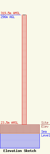
| Elevation Info |
Site Elevation: 23.5 meters (77 ft) |
| Height of Structure: 296 meters (971 feet) |
| Overall Height Above Ground: 296 meters (971 feet) |
| Overall Height Above Mean Sea Level: 319.5 meters (1048 feet) |
| Owner Info | Entravision - Texas Limited Partnership
2425 Olympic Blvd., Suite 6000 W
Santa Monica, CA 90404
(310) 447-3870
wulloa@entravision.com |
| Contact Info | Thompson HIne LLP
Suite 700
Washington, DC 20036
Barry Friedman
(202) 331-8800
barry.friedman@thompsonhine.com |
