|
|
Antenna Structure Registration 1051460 |
 |
Registration Info | Registration Number: 1051460 |
| File Number: A1351414 |
| FAA Study: 2025-AGL-14018-OE |
| FAA Issue Date: 12/15/2025 |
| Status: Constructed |
| Date Constructed: 08/01/1993 |
| NEPA: N |
Structure Info
| Structure Type: GTOWER |
| Structure Coordinates: 40-46-22.0 N 89-44-50.0 W (NAD 83) |
| Structure Coordinates: 40-46-21.9 N 89-44-49.6 W (Converted to NAD 27) |
| Structure Address: 9700 W Civil Defense Rd Il-5692 |
| Structure City: Kickapoo, IL |
| Structure County: Peoria County |
| Painting & Lighting Info |
FAA Circular #: 70/7460-1M |
FAA Chapters: 4, 8, 15 |
| Elevation Info |
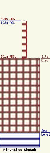
Site Elevation: 201 meters (659 ft) |
| Height of Structure: 102 meters (335 feet) |
| Overall Height Above Ground: 103 meters (338 feet) |
| Overall Height Above Mean Sea Level: 304 meters (997 feet) |
| Owner Info | VB Nimbus, LLC
22 W Atlantic Avenue
Delray Beach, FL 33444
(561) 406-4015
fcc-faa@verticalbridge.com |
| Contact Info | VB Nimbus, LLC
22 W Atlantic Avenue
Delray Beach, FL 33444
Richard Hickey
(561) 406-4015
fcc-faa@verticalbridge.com |
