|
|
Antenna Structure Registration 1052057 |
 |
Registration Info | Registration Number: 1052057 |
| File Number: A0090041 |
| FAA Study: FTW-OE-66-558 |
| FAA Issue Date: 05/10/1967 |
| Status: Constructed |
| Date Constructed: 01/14/1968 |
| NEPA: N |
Structure Info
| Structure Type: TOWER |
| Structure Coordinates: 32-24-48.4 N 100-6-26.3 W (NAD 83) |
| Structure Coordinates: 32-24-48.0 N 100-06-24.9 W (Converted to NAD 27) |
| Structure Address: 6.8 Miles Sw |
| Structure City: Merkel, TX |
| Structure County: Taylor County |
| Painting & Lighting Info |
FAA Circular #: |
FCC Paragraph(s): 1, 3, 8, 17, 21 |
Remarks: RED LIGHTS/PAINT |
| Elevation Info |
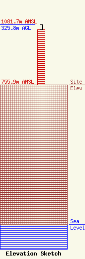
Site Elevation: 755.9 meters (2480 ft) |
| Height of Structure: 299.2 meters (982 feet) |
| Overall Height Above Ground: 325.8 meters (1069 feet) |
| Overall Height Above Mean Sea Level: 1081.7 meters (3549 feet) |
| Owner Info | ABILENE-SWEETWATER BROADCASTING COMPANY DBA = KTXS-TV
4420 N. CLACK ST.
ABILENE, TX 79603
(915) 677-2281
MWILLIAM@KTXS.COM |
| Contact Info | Koteen & Naftalin, L..L. P.
1150 Connecticut Ave, NW, Ste 1000
Washington, DC 20036
Linda Hartman
(202) 467-5700
linda.hartman@koteen.com |
