|
|
Antenna Structure Registration 1052096 |
 |
Registration Info | Registration Number: 1052096 |
| File Number: A1352557 |
| FAA Study: 86-ASW-0114-OE |
| FAA Issue Date: 01/30/1986 |
| Status: Constructed |
| Date Constructed: 04/01/1983 |
| FAA EMI: N |
| NEPA: N |
Structure Info
| Structure Type: TOWER |
| Structure Coordinates: 32-17-20.0 N 95-11-57.0 W (NAD 83) |
| Structure Coordinates: 32-17-19.5 N 95-11-56.2 W (Converted to NAD 27) |
| Structure Address: 0.5 Miles East Of Fr 848 On Old Omen Rd. |
| Structure City: Tyler, TX |
| Structure County: Smith County |
| Painting & Lighting Info |
FCC Paragraph(s): 1, 3, 12, 21 |
| Elevation Info |
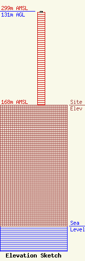
Site Elevation: 168 meters (551 ft) |
| Height of Structure: 130 meters (427 feet) |
| Overall Height Above Ground: 131 meters (430 feet) |
| Overall Height Above Mean Sea Level: 299 meters (981 feet) |
| Owner Info | Townsquare Media Tyler, LLC
4 Manhattanville Road
Purchase, NY 10577
(203) 861-0900
fcccontact@townsquaremedia.com |
| Contact Info | Townsquare Media Tyler, LLC
4 Manhattanville Road
Purchase, NY 10577
(203) 861-0900
fcccontact@townsquaremedia.com |
