|
|
Antenna Structure Registration 1052145 |
 |
Registration Info | Registration Number: 1052145 |
| File Number: A1095734 |
| FAA Study: 98-ASO-3631-OE |
| FAA Issue Date: 06/09/1998 |
| Status: Constructed |
| Date Constructed: 01/01/1981 |
| FAA EMI: N |
| NEPA: N |
Structure Info
| Structure Type: TOWER |
| Structure Coordinates: 32-53-48.0 N 83-32-5.0 W (NAD 83) |
| Structure Coordinates: 32-53-47.5 N 83-32-05.4 W (Converted to NAD 27) |
| Structure Address: Hwy. 49 1.5 Miles (2.4km) N. Of Jones/bibb Co. Line |
| Structure City: Macon, GA |
| Structure County: Jones County |
| Painting & Lighting Info |
FAA Circular #: 70/7460-1J |
FAA Chapters: 3, 4, 5, 13 |
| Elevation Info |
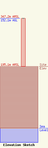
Site Elevation: 195.1 meters (640 ft) |
| Height of Structure: 152.1 meters (499 feet) |
| Overall Height Above Ground: 152.1 meters (499 feet) |
| Overall Height Above Mean Sea Level: 347.2 meters (1139 feet) |
| Owner Info | Clearview Tower Company II, LLC
26 Yolanda Drive
Edison, NJ 08817
(732) 744-0652
smejia@clearviewtower.net |
| Contact Info | Clearview Tower Company II, LLC
26 Yolanda Drive
Edison, NJ 08817
Steven Mejia
(732) 744-0652
smejia@clearviewtower.net |
