|
|
Antenna Structure Registration 1052552 |
 |
Registration Info | Registration Number: 1052552 |
| File Number: A1308540 |
| FAA Study: 81-SW-1435-OE |
| FAA Issue Date: 07/13/1981 |
| Status: Dismantled |
| Date Constructed: 06/01/1987 |
| FAA EMI: N |
| NEPA: N |
Structure Info
|
| Structure Coordinates: 29-45-27.0 N 95-20-20.0 W (NAD 83) |
| Structure Coordinates: 29-45-26.2 N 95-20-19.2 W (Converted to NAD 27) |
| Structure Address: Ennis Street |
| Structure City: Houston, TX |
| Structure County: Harris County |
| Painting & Lighting Info |
FCC Paragraph(s): 1, 3, 7, 16, 21 |
Remarks: RED LIGHTS/PAINT |
| Elevation Info |
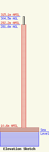
Site Elevation: 10.6 meters (35 ft) |
| Height of Structure: 281.6 meters (924 feet) |
| Overall Height Above Ground: 304.5 meters (999 feet) |
| Overall Height Above Mean Sea Level: 315.1 meters (1034 feet) |
| Owner Info | SBA Towers XI, LLC
8051 Congress Avenue
Boca Raton, FL 33487
(561) 995-7670
ERoach@sbasite.com |
| Contact Info | SBA Towers XI, LLC
8051 Congress Avenue
Boca Raton, FL 33487
(561) 995-7670
ERoach@sbasite.com |
