|
|
Antenna Structure Registration 1052665 |
 |
Registration Info | Registration Number: 1052665 |
| File Number: A0061989 |
| FAA Study: 97-AEA-2618-OE |
| FAA Issue Date: 09/30/1997 |
| Status: Constructed |
| Date Constructed: 01/01/1983 |
| NEPA: N |
Structure Info
| Structure Type: 5TA1 |
| Structure Coordinates: 40-52-51.0 N 76-49-6.0 W (NAD 83) |
| Structure Coordinates: 40-52-50.7 N 76-49-07.1 W (Converted to NAD 27) |
| Structure Address: Twr 1 - County Line Road |
| Structure City: Selinsgrove, PA |
| Structure County: Snyder County |
| Painting & Lighting Info |
FAA Circular #: 70/7460-1J |
FAA Chapters: 3, 4, 5, 13 |
| Elevation Info |
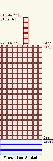
Site Elevation: 243.8 meters (800 ft) |
| Height of Structure: 70.7 meters (232 feet) |
| Overall Height Above Ground: 71.6 meters (235 feet) |
| Overall Height Above Mean Sea Level: 315.4 meters (1035 feet) |
| Owner Info | SUNBURY BROADCASTING CORPORATION
R.D. 2, COUNTY LINE ROAD
1070
SUNBURY, PA 17801
(717) 286-5838
|
