|
|
Antenna Structure Registration 1053074 |
 |
Registration Info | Registration Number: 1053074 |
| File Number: A0568813 |
| FAA Study: NOS 23-1333 |
| FAA Issue Date: 01/01/1999 |
| Status: Constructed |
| Date Constructed: 01/01/1987 |
| FAA EMI: N |
| NEPA: N |
Structure Info
| Structure Type: TOWER |
| Structure Coordinates: 41-50-45.0 N 83-27-50.0 W (NAD 83) |
| Structure Coordinates: 41-50-44.8 N 83-27-50.2 W (Converted to NAD 27) |
| Structure Address: Near Hillcrest Orchard |
| Structure City: Hillcrest Orchard, MI |
| Structure County: Monroe County |
| Painting & Lighting Info |
FCC Paragraph(s): 1, 3, 4, 13 |
Remarks: RED LIGHTS/PAINT. |
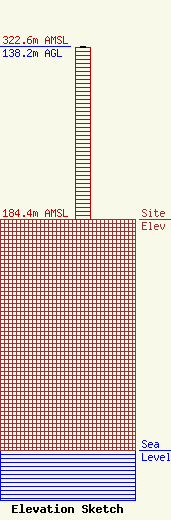
| Elevation Info |
Site Elevation: 184.4 meters (605 ft) |
| Height of Structure: 137.3 meters (450 feet) |
| Overall Height Above Ground: 138.2 meters (453 feet) |
| Overall Height Above Mean Sea Level: 322.6 meters (1058 feet) |
| Owner Info | Cumulus Broadcasting LLC
3280 Peachtree Road, Suite 2300
Atlanta, GA 30305
(404) 949-0700
gary.kline@cumulus.com |
| Contact Info | Graham Brock, Inc.
24466
St. Simons Island, GA 31522-7466
Marilyn Matheny
(912) 638-8028
marilyn@grahambrock.com |
