|
|
Antenna Structure Registration 1053336 |
 |
Registration Info | Registration Number: 1053336 |
| File Number: A1145044 |
| FAA Study: 97-AEA-3713-OE |
| FAA Issue Date: 01/22/1998 |
| Status: Constructed |
| Date Constructed: 01/01/1968 |
| FAA EMI: N |
| NEPA: N |
Structure Info
|
| Structure Coordinates: 38-23-12.0 N 75-17-26.0 W (NAD 83) |
| Structure Coordinates: 38-23-11.6 N 75-17-27.3 W (Converted to NAD 27) |
| Structure Address: .75 Se Off St Rt 346 |
| Structure City: Whaleysville, MD |
| Structure County: Worcester County |
| Painting & Lighting Info |
FAA Circular #: 70/7460-1J |
FAA Chapters: 3, 4, 5, 13 |
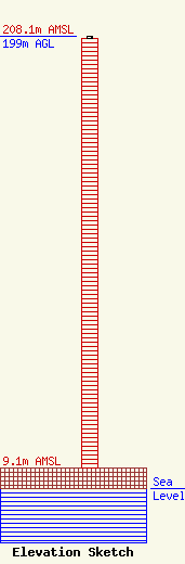
| Elevation Info |
Site Elevation: 9.1 meters (30 ft) |
| Height of Structure: 198 meters (650 feet) |
| Overall Height Above Ground: 199 meters (653 feet) |
| Overall Height Above Mean Sea Level: 208.1 meters (683 feet) |
| Owner Info | Pep Maxwell, LLC
28244 Bryans Store Road
Georgetown, DE 19947
(302) 745-5728
walt.barcus@gmail.com |
| Contact Info | Pep Maxwell, LLC
28244 Bryans Store Road
Georgetown, DE 19947
Walt Barcus
(302) 745-5728
walt.barcus@gmail.com |
