|
|
Antenna Structure Registration 1053879 |
 |
Registration Info | Registration Number: 1053879 |
| File Number: A0063380 |
| FAA Study: 73-SO-1784-OE |
| FAA Issue Date: 08/21/1973 |
| Status: Constructed |
| Date Constructed: 01/01/1973 |
| NEPA: N |
Structure Info
| Structure Type: TOWER |
| Structure Coordinates: 34-31-4.0 N 79-6-18.0 W (NAD 83) |
| Structure Coordinates: 34-31-03.4 N 79-06-18.9 W (Converted to NAD 27) |
| Structure Address: Hwy 41 N |
| Structure City: Fairmont, NC |
| Structure County: Robeson County |
| Painting & Lighting Info |
FCC Paragraph(s): 1, 3, 12, 21 |
Remarks: RED LIGHTS/PAINT |
| Elevation Info |
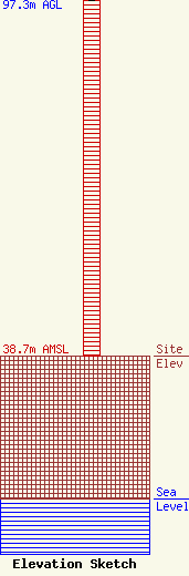
Site Elevation: 38.7 meters (127 ft) |
| Height of Structure: 96.3 meters (316 feet) |
| Overall Height Above Ground: 97.3 meters (319 feet) |
| Overall Height Above Mean Sea Level: 136 meters (446 feet) |
| Owner Info | PRO MEDIA INC DBA = WFMO AM
665
FAIRMONT, NC 28340
(910) 628-6781
|
