|
|
Antenna Structure Registration 1054027 |
 |
Registration Info | Registration Number: 1054027 |
| File Number: A0063536 |
| FAA Study: 96-ASW-1031-OE |
| FAA Issue Date: 05/08/1997 |
| Status: Constructed |
| Date Constructed: 01/01/1997 |
| NEPA: N |
Structure Info
| Structure Type: TOWER |
| Structure Coordinates: 33-23-43.0 N 96-35-51.0 W (NAD 83) |
| Structure Coordinates: 33-23-42.6 N 96-35-50.0 W (Converted to NAD 27) |
| Structure Address: 970 Collin County Rd 222 |
| Structure City: Anna, TX |
| Structure County: Collin County |
| Painting & Lighting Info |
FAA Circular #: 70/7460-1J |
FAA Chapters: 3, 4, 5, 13 |
| Elevation Info |
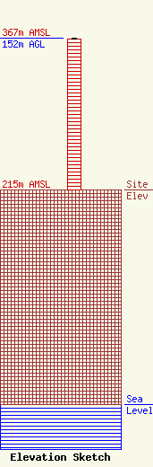
Site Elevation: 215 meters (705 ft) |
| Height of Structure: 151 meters (495 feet) |
| Overall Height Above Ground: 152 meters (499 feet) |
| Overall Height Above Mean Sea Level: 367 meters (1204 feet) |
| Owner Info | METRO BROADCASTERS TEXAS INC
940670
PLANO, TX 75094
(972) 396-1640
|
