|
|
Antenna Structure Registration 1054292 |
 |
Registration Info | Registration Number: 1054292 |
| File Number: A0063838 |
| FAA Study: 98-ASO-1452-OE |
| Status: Constructed |
| Date Constructed: 01/01/1971 |
| NEPA: N |
Structure Info
| Structure Type: TOWER |
| Structure Coordinates: 35-9-16.0 N 89-49-20.0 W (NAD 83) |
| Structure Coordinates: 35-09-15.7 N 89-49-19.7 W (Converted to NAD 27) |
| Structure Address: 7192 Raleigh La Grange Rd |
| Structure City: Memphis, TN |
| Structure County: Shelby County |
| Painting & Lighting Info |
FAA Circular #: 70/7460-1J |
FAA Chapters: 3, 4, 5, 13 |
| Elevation Info |
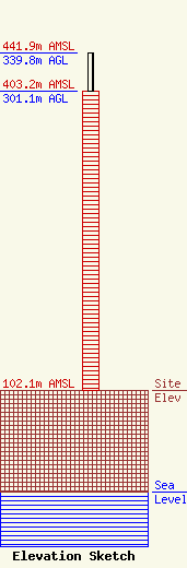
Site Elevation: 102.1 meters (335 ft) |
| Height of Structure: 301.1 meters (988 feet) |
| Overall Height Above Ground: 339.8 meters (1115 feet) |
| Overall Height Above Mean Sea Level: 441.9 meters (1450 feet) |
| Owner Info | MID SOUTH PUBLIC COMMUNICATIONS FOUNDATION DBA = WKNO TV FM
900 S GETWELL ST
MEMPHIS, TN 38111
(901) 458-2521
|
