|
|
Antenna Structure Registration 1054503 |
 |
Registration Info | Registration Number: 1054503 |
| File Number: A0064120 |
| FAA Study: 95-AGL-3149-OE |
| Status: Constructed |
| Date Constructed: 05/01/1992 |
| NEPA: N |
Structure Info
| Structure Type: TOWER |
| Structure Coordinates: 40-20-21.0 N 88-24-18.0 W (NAD 83) |
| Structure Coordinates: 40-20-20.9 N 88-24-17.8 W (Converted to NAD 27) |
| Structure Address: 2 Mi Se Of Foosland |
| Structure City: Fisher, IL |
| Structure County: Champaign County |
| Painting & Lighting Info |
FAA Circular #: 70/7460-1H |
FAA Chapters: 3, 4, 5, 13 |
| Elevation Info |
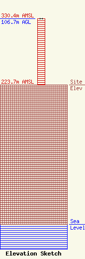
Site Elevation: 223.7 meters (734 ft) |
| Height of Structure: 106.7 meters (350 feet) |
| Overall Height Above Ground: 106.7 meters (350 feet) |
| Overall Height Above Mean Sea Level: 330.4 meters (1084 feet) |
| Owner Info | EASTERN ILLINI ELECTRIC COOPERATIVE
96
PAXTON, IL 60957
(217) 379-2131
|
