|
|
Antenna Structure Registration 1054542 |
 |
Registration Info | Registration Number: 1054542 |
| File Number: A0780542 |
| FAA Study: 98-ASW-2460-OE |
| FAA Issue Date: 06/30/1998 |
| Status: Constructed |
| Date Constructed: 03/11/1991 |
| FAA EMI: N |
| NEPA: N |
Structure Info
| Structure Type: TOWER |
| Structure Coordinates: 26-15-7.0 N 97-55-23.0 W (NAD 83) |
| Structure Coordinates: 26-15-05.7 N 97-55-22.0 W (Converted to NAD 27) |
| Structure Address: 1.2 Km. West North West Of Junction Of Rt. 491 And Mile 13.5 Road |
| Structure City: Lavilla, TX |
| Structure County: Hidalgo County |
| Painting & Lighting Info |
FCC Paragraph(s): 1, 3, 6, 15, 21 |
Remarks: HIGH INTENSITY WHITE LIGHTS - PRIOR FAA 86-ASW-1921-OE |
| Elevation Info |
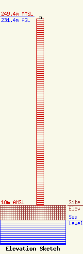
Site Elevation: 18 meters (59 ft) |
| Height of Structure: 229.1 meters (752 feet) |
| Overall Height Above Ground: 231.4 meters (759 feet) |
| Overall Height Above Mean Sea Level: 249.4 meters (818 feet) |
| Owner Info | Entravision - Texas Limited Partnership
Suite 6000W, 2425 Olympic Boulevard
Santa Monica, CA 90404
(310) 447-3870
wulloa@entravision.com |
| Contact Info | Thompson HIne LLP
Suite 700
Washington, DC 20036
Barry Friedman
(202) 331-8800
barry.friedman@thompsonhine.com |
