|
|
Antenna Structure Registration 1055303 |
 |
Registration Info | Registration Number: 1055303 |
| File Number: A1095490 |
| FAA Study: 78-AEA-313-OE |
| FAA Issue Date: 01/01/1978 |
| Status: Constructed |
| Date Constructed: 01/01/1978 |
| FAA EMI: N |
| NEPA: N |
Structure Info
| Structure Type: TOWER |
| Structure Coordinates: 42-3-4.0 N 78-25-10.0 W (NAD 83) |
| Structure Coordinates: 42-03-03.8 N 78-25-10.9 W (Converted to NAD 27) |
| Structure Address: Savage Hollow Rd |
| Structure City: Olean, NY |
| Structure County: Cattaraugus County |
| Painting & Lighting Info |
FCC Paragraph(s): 1, 3, 11, 21 |
Remarks: RED LIGHTS/PAINT |
| Elevation Info |
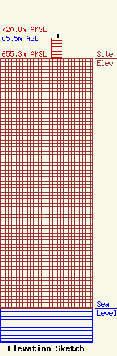
Site Elevation: 655.3 meters (2150 ft) |
| Height of Structure: 54.8 meters (180 feet) |
| Overall Height Above Ground: 65.5 meters (215 feet) |
| Overall Height Above Mean Sea Level: 720.8 meters (2365 feet) |
| Owner Info | Novia Communications, LLC
38 Evans Drive
Glen Head, NY 11545
(516) 626-7613
finnbriand@gmail.com |
| Contact Info | Smithwick & Belendiuk, P.C.
5028 WISCONSIN AVE NW
WASHINGTON, DC 20016-4118
Mark Denbo
(202) 350-9656
mdenbo@fccworld.com |
