|
|
Antenna Structure Registration 1055650 |
 |
Registration Info | Registration Number: 1055650 |
| File Number: A0065433 |
| FAA Study: 98-ANE-0548-OE |
| FAA Issue Date: 02/01/1999 |
| Status: Constructed |
| Date Constructed: 01/01/1983 |
| NEPA: N |
Structure Info
| Structure Type: TOWER |
| Structure Coordinates: 41-33-44.0 N 72-50-40.0 W (NAD 83) |
| Structure Coordinates: 41-33-43.6 N 72-50-41.6 W (Converted to NAD 27) |
| Structure Address: Site Is Located Atop West Peak, Transmitter Farm |
| Structure City: Meridan, CT |
| Structure County: New Haven County |
| Painting & Lighting Info |
FAA Chapters: NONE |
Remarks: Removed expiration date from determination. Scenario 1./jjs/case#635066 |
| Elevation Info |
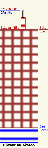
Site Elevation: 312.1 meters (1024 ft) |
| Height of Structure: 37.2 meters (122 feet) |
| Overall Height Above Ground: 59 meters (194 feet) |
| Overall Height Above Mean Sea Level: 371.1 meters (1218 feet) |
| Owner Info | THOMAS BROTHERS, INC DBA = WZMX-FM, CBA#14, THOMAS BROTHERS
79 BALDWIN AVENUE
WATERBURY, CT 06706
(203) 755-1121
|
