|
|
Antenna Structure Registration 1056147 |
 |
Registration Info | Registration Number: 1056147 |
| File Number: A1352112 |
| FAA Study: 2025-ANM-7261-OE |
| FAA Issue Date: 12/23/2025 |
| Status: Granted |
| Date Constructed: 10/16/1998 |
| NEPA: N |
Structure Info
| Structure Type: LTOWER |
| Structure Coordinates: 39-26-32.6 N 107-58-3.6 W (NAD 83) |
| Structure Coordinates: 39-26-32.7 N 107-58-01.3 W (Converted to NAD 27) |
| Structure Address: 3490 County Road 302 (90361) |
| Structure City: Parachute, CO |
| Structure County: Garfield County |
| Painting & Lighting Info |
FAA Chapters: NONE |
Remarks: PRIOR STUDY 2024-ANM-6488-OE |
| Elevation Info |
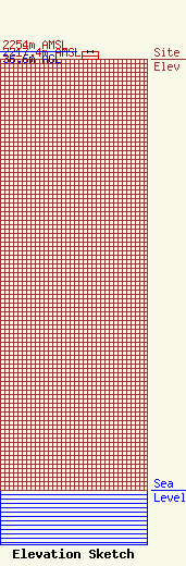
Site Elevation: 2217.4 meters (7275 ft) |
| Height of Structure: 36 meters (118 feet) |
| Overall Height Above Ground: 36.6 meters (120 feet) |
| Overall Height Above Mean Sea Level: 2254 meters (7395 feet) |
| Owner Info | American Towers LLC
10 Presidential Way
Woburn, MA 01801
(781) 926-4500
faa-fcc@americantower.com |
| Contact Info | American Towers LLC
10 Presidential Way
Woburn, MA 01801
(781) 926-4500
faa-fcc@americantower.com |
