|
|
Antenna Structure Registration 1056416 |
 |
Registration Info | Registration Number: 1056416 |
| File Number: A1342663 |
| FAA Study: 98-ASO-4722-OE |
| FAA Issue Date: 09/02/1998 |
| Status: Constructed |
| Date Constructed: 04/28/1997 |
| FAA EMI: N |
| NEPA: N |
Structure Info
| Structure Type: TOWER |
| Structure Coordinates: 38-14-38.0 N 85-45-33.0 W (NAD 83) |
| Structure Coordinates: 38-14-37.7 N 85-45-33.1 W (Converted to NAD 27) |
| Structure Address: South Fourth Street |
| Structure City: Louisville, KY |
| Structure County: Jefferson County |
| Painting & Lighting Info |
FAA Circular #: 70/7460-1J |
FAA Chapters: 3, 4, 5, 13 |
Remarks: PREV. 77-SO-0701-OE |
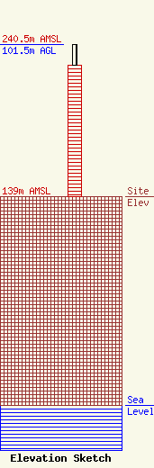
| Elevation Info |
Site Elevation: 139 meters (456 ft) |
| Height of Structure: 87.5 meters (287 feet) |
| Overall Height Above Ground: 101.5 meters (333 feet) |
| Overall Height Above Mean Sea Level: 240.5 meters (789 feet) |
| Owner Info | VB-S1 Assets, LLC
22 W Atlantic Avenue
Delray Beach, FL 33444
(561) 406-4015
fcc-faa@verticalbridge.com |
| Contact Info | VB-S1 Assets, LLC
22 W Atlantic Avenue
Delray Beach, FL 33444
Richard Hickey
(561) 406-4015
fcc-faa@verticalbridge.com |
