|
|
Antenna Structure Registration 1056646 |
 |
Registration Info | Registration Number: 1056646 |
| File Number: A1300205 |
| FAA Study: 98-AGL-4834-OE |
| FAA Issue Date: 02/23/1999 |
| Status: Constructed |
| Date Constructed: 10/31/1999 |
| FAA EMI: N |
| NEPA: N |
Structure Info
| Structure Type: TOWER |
| Structure Coordinates: 44-19-42.0 N 103-50-5.0 W (NAD 83) |
| Structure Coordinates: 44-19-42.1 N 103-50-03.3 W (Converted to NAD 27) |
| Structure Address: 3.7 Miles Southwest Of Lead, Atop Terry Peak |
| Structure City: Lead, SD |
| Structure County: Lawrence County |
| Painting & Lighting Info |
FAA Circular #: 70/7460-1J |
FAA Chapters: 3, 4, 5, 13 |
Remarks: Removed expiration date from determination. Scenario 1./jjs/case#635066 |
Remarks: PRIOR FAA 98-AGL-2646-OE |
Remarks: Removed expiration date from determination. Scenario 1./jjs/case#635066 |
| Elevation Info |
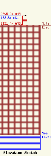
Site Elevation: 2121.4 meters (6960 ft) |
| Height of Structure: 182.9 meters (600 feet) |
| Overall Height Above Ground: 183.8 meters (603 feet) |
| Overall Height Above Mean Sea Level: 2305.2 meters (7563 feet) |
| Owner Info | Forum Communications Company
301 8th Street South
Fargo, ND 58103
(701) 237-6500
jrohrer@wday.com |
| Contact Info | Forum Communications Company
301 8th Street South
Fargo, ND 58103
Dave Johnson
(701) 237-6500
djohnson@wday.com |
