|
|
Antenna Structure Registration 1057048 |
 |
Registration Info | Registration Number: 1057048 |
| File Number: A1292721 |
| FAA Study: 2023-ASO-9003-OE |
| FAA Issue Date: 08/08/2023 |
| Status: Constructed |
| Date Constructed: 01/01/1975 |
| NEPA: N |
Structure Info
| Structure Type: LTOWER |
| Structure Coordinates: 33-47-55.4 N 84-23-12.7 W (NAD 83) |
| Structure Coordinates: 33-47-55.0 N 84-23-13.0 W (Converted to NAD 27) |
| Structure Address: 1601 West Peachtree St., N.e. (#207737) |
| Structure City: Atlanta, GA |
| Structure County: Fulton County |
| Painting & Lighting Info |
FAA Circular #: 70/7460-1M |
FAA Chapters: 4, 8, 15 |
Remarks: OM&L to remain the same as prior studies = A MED-DUAL SYSTEM |
Remarks: PRIOR STUDIES 1998-ASO-4181-OE / 2021-ASO-47443-OE |
Remarks: OM&L to remain the same as prior studies = A MED-DUAL SYSTEM |
| Elevation Info |
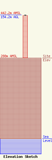
Site Elevation: 288 meters (945 ft) |
| Height of Structure: 151.8 meters (498 feet) |
| Overall Height Above Ground: 154.2 meters (506 feet) |
| Overall Height Above Mean Sea Level: 442.2 meters (1451 feet) |
| Owner Info | American Towers LLC
10 Presidential Way
Woburn, MA 01801
(781) 926-4500
faa-fcc@americantower.com |
| Contact Info | American Towers LLC
10 Presidential Way
Woburn, MA 01801
(781) 926-4500
faa-fcc@americantower.com |
