|
|
Antenna Structure Registration 1057130 |
 |
Registration Info | Registration Number: 1057130 |
| File Number: A1070669 |
| FAA Study: 2013-AGL-2422-OE |
| FAA Issue Date: 04/25/2013 |
| Status: Constructed |
| Date Constructed: 04/17/2017 |
| NEPA: N |
Structure Info
| Structure Type: LTOWER |
| Structure Coordinates: 39-35-38.0 N 88-50-45.0 W (NAD 83) |
| Structure Coordinates: 39-35-37.9 N 88-50-44.7 W (Converted to NAD 27) |
| Structure Address: 1 Mile S. |
| Structure City: Prairie Home, IL |
| Structure County: Shelby County |
| Painting & Lighting Info |
FCC Paragraph(s): 1, 3, 4, 13, 21 |
Remarks: PRIOR STUDY 1998-AGL-3530-OE OM&L TO REMAIN RED LIGHTS AND PAINT 70/7460-1. ADD SPECIAL CONDITION FOR LIGHTING DEVIATION. |
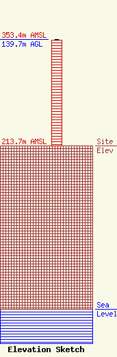
| Elevation Info |
Site Elevation: 213.7 meters (701 ft) |
| Height of Structure: 139.1 meters (456 feet) |
| Overall Height Above Ground: 139.7 meters (458 feet) |
| Overall Height Above Mean Sea Level: 353.4 meters (1159 feet) |
| Owner Info | CROMWELL GROUP, INC. OF ILLINOIS
150846
NASHVILLE, TN 37215
(615) 361-7560
budbayard@aol.com |
| Contact Info | CROMWELL GROUP, INC. OF ILLINOIS
150846
NASHVILLE, TN 37215
Bayard Walters
(615) 361-7560
budbayard@aol.com |
