|
|
Antenna Structure Registration 1057132 |
 |
Registration Info | Registration Number: 1057132 |
| File Number: A1068983 |
| FAA Study: 98-AGL-3159-OE |
| FAA Issue Date: 07/23/1998 |
| Status: Constructed |
| Date Constructed: 11/01/1994 |
| NEPA: N |
Structure Info
| Structure Type: TOWER |
| Structure Coordinates: 39-36-39.0 N 88-41-32.0 W (NAD 83) |
| Structure Coordinates: 39-36-38.9 N 88-41-31.8 W (Converted to NAD 27) |
| Structure Address: 2.7 Miles S.e. |
| Structure City: Kirksville, IL |
| Structure County: Moultrie County |
| Painting & Lighting Info |
FAA Circular #: 70/7460-1H |
FAA Chapters: 3, 4, 6, 13 |
| Elevation Info |
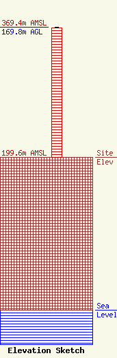
Site Elevation: 199.6 meters (655 ft) |
| Height of Structure: 169.2 meters (555 feet) |
| Overall Height Above Ground: 169.8 meters (557 feet) |
| Overall Height Above Mean Sea Level: 369.4 meters (1212 feet) |
| Owner Info | THE CROMWELL GROUP, INC. OF ILLINOIS
1824 Murfreesboro Road
150846
Nashville, TN 37215
(615) 361-7560
budbayard@aol.com |
| Contact Info | The Cromwell Group
1824 Murfreesboro Road
150846
Nashville, TN 37215
Bayard Walters
(615) 361-7560
budbayard@aol.com |
