|
|
Antenna Structure Registration 1057461 |
 |
Registration Info | Registration Number: 1057461 |
| File Number: A1146712 |
| FAA Study: 98-AGL-5263-OE |
| FAA Issue Date: 12/02/1998 |
| Status: Constructed |
| Date Constructed: 10/10/1997 |
| FAA EMI: N |
| NEPA: N |
Structure Info
| Structure Type: TOWER |
| Structure Coordinates: 44-31-26.0 N 88-19-54.0 W (NAD 83) |
| Structure Coordinates: 44-31-26.0 N 88-19-53.6 W (Converted to NAD 27) |
| Structure Address: 947 N Main St |
| Structure City: Seymour, WI |
| Structure County: Outagamie County |
| Painting & Lighting Info |
FAA Circular #: 70/7460-1H |
FAA Chapters: 3, 4, 5, 13 |
Remarks: OM&L TO REMAIN RED/LIGHTS/PAINT AS PER PREVIOUS FAA 95-AGL-1811-OE. |
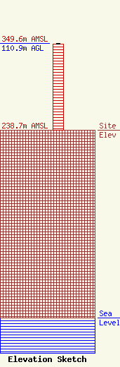
| Elevation Info |
Site Elevation: 238.7 meters (783 ft) |
| Height of Structure: 110 meters (361 feet) |
| Overall Height Above Ground: 110.9 meters (364 feet) |
| Overall Height Above Mean Sea Level: 349.6 meters (1147 feet) |
| Owner Info | Woodward Communications Inc.
2800 East College Avenue
1519
Appleton, WI 54912-1519
(920) 831-5659
sbrown@wcinet.com |
| Contact Info | Woodward Communications Inc.
2800 East College Avenue
1519
Appleton, WI 54912-1519
(920) 831-5659
sbrown@wcinet.com |
