|
|
Antenna Structure Registration 1057600 |
 |
Registration Info | Registration Number: 1057600 |
| File Number: A0691350 |
| FAA Study: 98-ASO-4661-OE |
| FAA Issue Date: 10/22/1998 |
| Status: Dismantled |
| Date Constructed: 01/01/1939 |
| FAA EMI: N |
| NEPA: N |
Structure Info
| Structure Type: 2TA1 |
| Structure Coordinates: 32-49-22.0 N 79-58-47.0 W (NAD 83) |
| Structure Coordinates: 32-49-21.4 N 79-58-47.7 W (Converted to NAD 27) |
| Structure Address: Twr 1 - One Orange Grove Road |
| Structure City: Charleston, SC |
| Structure County: Charleston County |
| Painting & Lighting Info |
FAA Circular #: 70/7460-1J |
FAA Chapters: 3, 4, 5, 13 |
Remarks: TOWER 1 OF 2TA. PREV. 89-ASO-0243-OE |
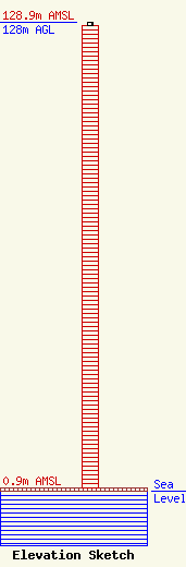
| Elevation Info |
Site Elevation: 0.9 meters (3 ft) |
| Height of Structure: 127.1 meters (417 feet) |
| Overall Height Above Ground: 128 meters (420 feet) |
| Overall Height Above Mean Sea Level: 128.9 meters (423 feet) |
| Owner Info | Citadel Broadcasting Company
7201 West Lake Mead Blvd. Suite 400
Las Vegas, NV 89128
(702) 804-5200
license.management@citcomm.com |
| Contact Info | Citadel Broadcasting Company - Charleston
4230 Faber Place Drive, Suite 100
Charleston, SC 29405
Chief Engineer
(843) 277-1200
|
