|
|
Antenna Structure Registration 1057623 |
 |
Registration Info | Registration Number: 1057623 |
| File Number: A1086848 |
| FAA Study: 2017-AEA-6871-OE |
| FAA Issue Date: 07/14/2017 |
| Status: Constructed |
| Date Constructed: 10/16/1999 |
| NEPA: N |
Structure Info
| Structure Type: GTOWER |
| Structure Coordinates: 37-15-3.8 N 81-11-22.8 W (NAD 83) |
| Structure Coordinates: 37-15-03.4 N 81-11-23.5 W (Converted to NAD 27) |
| Structure Address: 320 East River Mountain Rd (va09074-a) |
| Structure City: Bluefield, VA |
| Structure County: Bland County |
| Painting & Lighting Info |
FAA Circular #: 70/7460-1L |
FAA Chapters: 4, 8, 12 |
Remarks: PRIOR STUDY 2006-AEA-4411-OE |
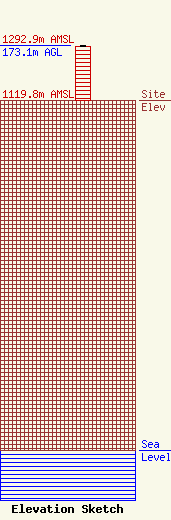
| Elevation Info |
Site Elevation: 1119.8 meters (3674 ft) |
| Height of Structure: 171.9 meters (564 feet) |
| Overall Height Above Ground: 173.1 meters (568 feet) |
| Overall Height Above Mean Sea Level: 1292.9 meters (4242 feet) |
| Owner Info | SBA Towers, LLC
8051 Congress Avenue
Boca Raton, FL 33487
(561) 995-7670
ERoach@sbasite.com |
| Contact Info | SBA Towers, LLC
8051 Congress Avenue
Boca Raton, FL 33487
Edward Roach
(561) 995-7670
ERoach@sbasite.com |
