|
|
Antenna Structure Registration 1057687 |
 |
Registration Info | Registration Number: 1057687 |
| File Number: A0478311 |
| FAA Study: 2005-ASW-5047-OE |
| FAA Issue Date: 09/23/2005 |
| Status: Constructed |
| Date Constructed: 11/29/2005 |
| FAA EMI: N |
| NEPA: N |
Structure Info
| Structure Type: TOWER |
| Structure Coordinates: 36-41-46.0 N 108-13-15.3 W (NAD 83) |
| Structure Coordinates: 36-41-46.0 N 108-13-13.0 W (Converted to NAD 27) |
| Structure Address: 1.85 Miles South Of The Intersection Of Sr 371 And Murray Drive, San Juan County |
| Structure City: Farmington, NM |
| Structure County: San Juan County |
| Painting & Lighting Info |
FAA Circular #: 70/7460-1K |
FAA Chapters: 3, 4, 5, 12 |
Remarks: Removed expiration date from determination. Scenario 1./jjs/case#635066 |
Remarks: PRIOR STUDY 2004-ASW-2160-OE |
| Elevation Info |
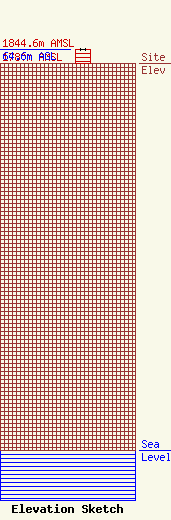
Site Elevation: 1780 meters (5840 ft) |
| Height of Structure: 63.7 meters (209 feet) |
| Overall Height Above Ground: 64.6 meters (212 feet) |
| Overall Height Above Mean Sea Level: 1844.6 meters (6052 feet) |
| Owner Info | AYOUB, FAREED
1105 WEST APACHE
FARMINGTON, NM 87401
(505) 327-7202
|
