|
|
Antenna Structure Registration 1057963 |
 |
Registration Info | Registration Number: 1057963 |
| File Number: A1113892 |
| FAA Study: 2007-ACE-85-OE |
| FAA Issue Date: 02/21/2007 |
| Status: Constructed |
| Date Constructed: 02/22/2007 |
| FAA EMI: N |
| NEPA: N |
Structure Info
| Structure Type: TOWER |
| Structure Coordinates: 42-35-12.0 N 96-13-19.0 W (NAD 83) |
| Structure Coordinates: 42-35-12.0 N 96-13-17.9 W (Converted to NAD 27) |
| Structure Address: 1.6 Km Ne Of Rtes K42 And C70 Section 25 |
| Structure City: Plymouth County, IA |
| Structure County: Plymouth County |
| Painting & Lighting Info |
FAA Circular #: 70/7460-1K |
FAA Chapters: 4, 7, 12 |
Remarks: PRIOR STUDY 1998-ACE-1240-OE |
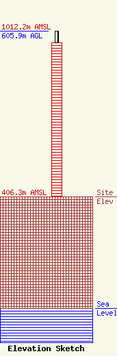
| Elevation Info |
Site Elevation: 406.3 meters (1333 ft) |
| Height of Structure: 563 meters (1847 feet) |
| Overall Height Above Ground: 605.9 meters (1988 feet) |
| Overall Height Above Mean Sea Level: 1012.2 meters (3321 feet) |
| Owner Info | Heartland Tower Company, L.L.C
2001 L Street NW
Washington, DC 20036
(202) 429-8970
pcicelski@lermansenter.com |
| Contact Info | Lerman Senter PLLC
2001 L Street NW
Washington, DC 20036
Paul A. Cicleski
(202) 429-8970
pcicelski@lermansenter.com |
