|
|
Antenna Structure Registration 1058737 |
 |
Registration Info | Registration Number: 1058737 |
| File Number: A1381994 |
| FAA Study: 95-AGL-1998-OE |
| FAA Issue Date: 05/19/1995 |
| Status: Constructed |
| Date Constructed: 05/19/1995 |
| FAA EMI: N |
| NEPA: N |
Structure Info
| Structure Type: TOWER |
| Structure Coordinates: 43-53-38.0 N 102-13-51.0 W (NAD 83) |
| Structure Coordinates: 43-53-38.0 N 102-13-49.4 W (Converted to NAD 27) |
| Structure Address: 6 Miles South Of Wall Sd |
| Structure City: Wall, SD |
| Structure County: Pennington County |
| Painting & Lighting Info |
FAA Circular #: 70/7460-1H |
FAA Chapters: 4, 6, 13 |
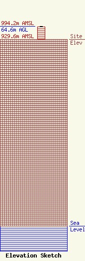
| Elevation Info |
Site Elevation: 929.6 meters (3050 ft) |
| Height of Structure: 60.6 meters (199 feet) |
| Overall Height Above Ground: 64.6 meters (212 feet) |
| Overall Height Above Mean Sea Level: 994.2 meters (3262 feet) |
| Owner Info | Western Area Power Administration
281213
Lakewood, CO 80228-8213
(720) 962-7396
Stefaniak@WAPA.GOV |
| Contact Info | Western Area Power Administration
281213
Lakewood, CO 80228-8213
Jon Stefaniak
(720) 962-7396
Stefaniak@WAPA.GOV |
