|
|
Antenna Structure Registration 1059002 |
 |
Registration Info | Registration Number: 1059002 |
| File Number: A1099763 |
| FAA Study: 93-AEA-1848-OE |
| FAA Issue Date: 01/26/1994 |
| Status: Constructed |
| Date Constructed: 10/20/1992 |
| FAA EMI: N |
| NEPA: N |
Structure Info
| Structure Type: 4TA1 |
| Structure Coordinates: 39-7-57.0 N 77-18-16.0 W (NAD 83) |
| Structure Coordinates: 39-07-56.6 N 77-18-17.1 W (Converted to NAD 27) |
| Structure Address: Twr 1 - 16925 Black Rock Rd |
| Structure City: Germantown, MD |
| Structure County: Montgomery County |
| Painting & Lighting Info |
FAA Circular #: 70/7460-1H |
FAA Chapters: 4, 8, 13 |
Remarks: 4 TOWER ARRAY. TOWERS 1 & 3 HAVE A DUAL MED INT LIGHT SYSTEM. TOWERS 2 & 4 DO NOT REQUIRE OM&L. |
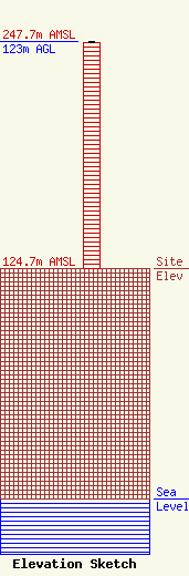
| Elevation Info |
Site Elevation: 124.7 meters (409 ft) |
| Height of Structure: 122 meters (400 feet) |
| Overall Height Above Ground: 123 meters (404 feet) |
| Overall Height Above Mean Sea Level: 247.7 meters (813 feet) |
| Owner Info | Vertical Bridge Towers II, LLC
750 Park of Commerce Dr.
Boca Raton, FL 33487
(561) 406-4015
FCC-FAA@verticalbridge.com |
| Contact Info | Vertical Bridge Towers II, LLC
750 Park of Commerce Dr.
Boca Raton, FL 33487
Richard Hickey
(561) 406-4015
FCC-FAA@verticalbridge.com |
