|
|
Antenna Structure Registration 1059204 |
 |
Registration Info | Registration Number: 1059204 |
| File Number: A1248622 |
| FAA Study: 87-AWP-260-OE |
| FAA Issue Date: 12/08/1987 |
| Status: Constructed |
| Date Constructed: 01/01/1989 |
| NEPA: N |
Structure Info
| Structure Type: 3TA1 |
| Structure Coordinates: 34-0-41.0 N 117-11-6.0 W (NAD 83) |
| Structure Coordinates: 34-00-40.9 N 117-11-02.9 W (Converted to NAD 27) |
| Structure Address: Twr 1 - 28432 San Timoteo Road |
| Structure City: Redlands, CA |
| Structure County: San Bernardino County |
| Painting & Lighting Info |
FAA Chapters: NONE |
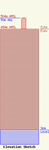
| Elevation Info |
Site Elevation: 454 meters (1490 ft) |
| Height of Structure: 50 meters (164 feet) |
| Overall Height Above Ground: 50 meters (164 feet) |
| Overall Height Above Mean Sea Level: 504 meters (1654 feet) |
| Owner Info | El Sembrador Ministries
20720 Marilla Street
Chatsworth, CA 91311
(773) 777-7773
rosiegomez@elsembrador.org |
| Contact Info | Law Office of Dennis J. Kelly
30628 Detroit Road, Box 278
Westlake, OH 44145
Dennis Kelly
(202) 293-2300
dkellyfcclaw1@comcast.net |
