|
|
Antenna Structure Registration 1059469 |
 |
Registration Info | Registration Number: 1059469 |
| File Number: A0069842 |
| FAA Study: 98-ASO-7242-OE |
| FAA Issue Date: 12/22/1998 |
| Status: Constructed |
| Date Constructed: 07/01/1991 |
| NEPA: N |
Structure Info
| Structure Type: TOWER |
| Structure Coordinates: 36-5-56.0 N 86-39-35.0 W (NAD 83) |
| Structure Coordinates: 36-05-55.8 N 86-39-35.0 W (Converted to NAD 27) |
| Structure Address: 1824 Murfreesboro Rd, 0.8 Miles E Of Donelson Pike And Murfreesboro Pike |
| Structure City: Antioch, TN |
| Structure County: Davidson County |
| Painting & Lighting Info |
FAA Chapters: NONE |
Remarks: Removed expiration date from determination. Scenario 1./jjs/case#635066 |
| Elevation Info |
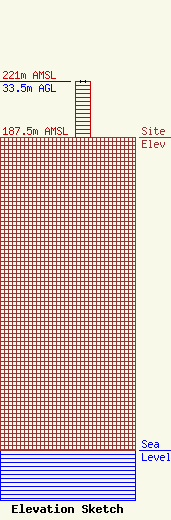
Site Elevation: 187.5 meters (615 ft) |
| Height of Structure: 33.5 meters (110 feet) |
| Overall Height Above Ground: 33.5 meters (110 feet) |
| Overall Height Above Mean Sea Level: 221 meters (725 feet) |
| Owner Info | THE CROMWELL GROUP, INC.
150846
NASHVILLE, TN 37215
(615) 361-7560
|
