|
|
Antenna Structure Registration 1059580 |
 |
Registration Info | Registration Number: 1059580 |
| File Number: A1344103 |
| FAA Study: 98-AGL-4803-OE |
| FAA Issue Date: 11/13/1998 |
| Status: Constructed |
| Date Constructed: 12/01/2006 |
| FAA EMI: N |
| NEPA: N |
Structure Info
| Structure Type: TOWER |
| Structure Coordinates: 46-48-37.0 N 100-44-11.0 W (NAD 83) |
| Structure Coordinates: 46-48-37.0 N 100-44-09.5 W (Converted to NAD 27) |
| Structure Address: 2 Mi 3.22 Km E |
| Structure City: Bismarck, ND |
| Structure County: Burleigh County |
| Painting & Lighting Info |
FCC Paragraph(s): 1, 3, 11, 21 |
Remarks: OM&L TO REMAIN RED LIGHTS/PAINT. |
| Elevation Info |
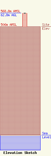
Site Elevation: 506 meters (1660 ft) |
| Height of Structure: 62.2 meters (204 feet) |
| Overall Height Above Ground: 62.8 meters (206 feet) |
| Overall Height Above Mean Sea Level: 568.8 meters (1866 feet) |
| Owner Info | Vertical Bridge CC AM, LLC
22 W Atlantic Avenue
Delray Beach, FL 33444
(561) 406-4015
fcc-faa@verticalbridge.com |
| Contact Info | Vertical Bridge CC AM, LLC
22 W Atlantic Avenue
Delray Beach, FL 33444
Richard Hickey
(561) 406-4015
fcc-faa@verticalbridge.com |
