|
|
Antenna Structure Registration 1059656 |
 |
Registration Info | Registration Number: 1059656 |
| File Number: A0215859 |
| FAA Study: 94-AEA-2006-OE |
| Status: Constructed |
| Date Constructed: 03/05/1975 |
| FAA EMI: N |
| NEPA: N |
Structure Info
| Structure Type: 3TA1 |
| Structure Coordinates: 39-52-38.0 N 75-27-21.0 W (NAD 83) |
| Structure Coordinates: 39-52-37.6 N 75-27-22.3 W (Converted to NAD 27) |
| Structure Address: Twr 1 - 12 Kent Road |
| Structure City: Aston, PA |
| Structure County: Delaware County |
| Painting & Lighting Info |
FAA Chapters: NONE |
| Elevation Info |
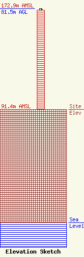
Site Elevation: 91.4 meters (300 ft) |
| Height of Structure: 80.6 meters (264 feet) |
| Overall Height Above Ground: 81.5 meters (267 feet) |
| Overall Height Above Mean Sea Level: 172.9 meters (567 feet) |
| Owner Info | Mount Ocean Media, L.L.C.
99 Clinton Road
West Caldwell, NJ 07006
(973) 852-0300
vicjoo@attglobal.net |
| Contact Info | Fleischman and Walsh, LLP
1400 16th Street, N.W. Suite 600
Washington, DC 20036
Arthur Harding
(202) 939-7900
aharding@fw-law.com |
