|
|
Antenna Structure Registration 1059698 |
 |
Registration Info | Registration Number: 1059698 |
| File Number: A0070086 |
| FAA Study: 84-ASO-2252-OE |
| FAA Issue Date: 11/05/1984 |
| Status: Constructed |
| Date Constructed: 12/15/1986 |
| NEPA: N |
Structure Info
| Structure Type: TOWER |
| Structure Coordinates: 30-44-49.0 N 89-3-30.0 W (NAD 83) |
| Structure Coordinates: 30-44-48.3 N 89-03-29.8 W (Converted to NAD 27) |
| Structure Address: 955 E. Old Wire Rd. |
| Structure City: Perkston, MS |
| Structure County: Stone County |
| Painting & Lighting Info |
FCC Paragraph(s): B, F, H |
Remarks: HIGH INTENSITY WHITE LIGHTS |
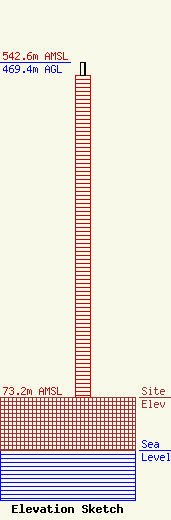
| Elevation Info |
Site Elevation: 73.2 meters (240 ft) |
| Height of Structure: 450.5 meters (1478 feet) |
| Overall Height Above Ground: 469.4 meters (1540 feet) |
| Overall Height Above Mean Sea Level: 542.6 meters (1780 feet) |
| Owner Info | MORRIS NETWORK OF MISSISSIPPI, INC.
14351 HWY 49N
GULFPORT, MS 39503
(228) 832-2525
|
