|
|
Antenna Structure Registration 1059748 |
 |
Registration Info | Registration Number: 1059748 |
| File Number: A1206197 |
| FAA Study: 2014-AGL-9552-OE |
| FAA Issue Date: 10/01/2014 |
| Status: Constructed |
| Date Constructed: 08/30/1974 |
Structure Info
| Structure Type: 2GTA1 |
| Structure Coordinates: 43-59-10.1 N 92-25-3.6 W (NAD 83) |
| Structure Coordinates: 43-59-10.2 N 92-25-03.0 W (Converted to NAD 27) |
| Structure Address: 30th Avenue, S.e. |
| Structure City: Rochester, MN |
| Structure County: Olmsted County |
| Painting & Lighting Info |
FCC Paragraph(s): 1, 3, 12, 21 |
Remarks: PRIOR STUDY 2014-AGL-4402-OE |
Remarks: Continue As Is OM&L = PAINT/RED LIGHTS |
Remarks: PRIOR STUDY 2014-AGL-4402-OE |
Remarks: Continue As Is OM&L = PAINT/RED LIGHTS |
| Elevation Info |
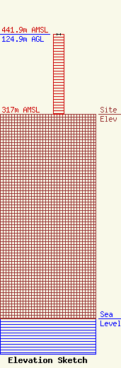
Site Elevation: 317 meters (1040 ft) |
| Height of Structure: 124.9 meters (410 feet) |
| Overall Height Above Ground: 124.9 meters (410 feet) |
| Overall Height Above Mean Sea Level: 441.9 meters (1450 feet) |
| Owner Info | Townsquare Media Rochester, LLC
1 Manhattanville Road
Purchase, NY 10577
(203) 861-0900
fcccontact@townsquaremedia.com |
| Contact Info | Townsquare Media Rochester, LLC
1 Manhattanville Road
Purchase, NY 10577
(203) 861-0900
fcccontact@townsquaremedia.com |
